Uta Gjertsen, met.no
Normal propagation conditions are ususally assumed when correcting radar reflectivity data for errors related to the VPR and beam blockage. This assumption is not always fullfilled since variations in the vertical profiles of temperature, pressure, and humidity affect radar beam propagation, especially when occuring at low elevation angles at the radar site. A beam blockage correction based on a standard atmoshpere might not be good enough in all cases.
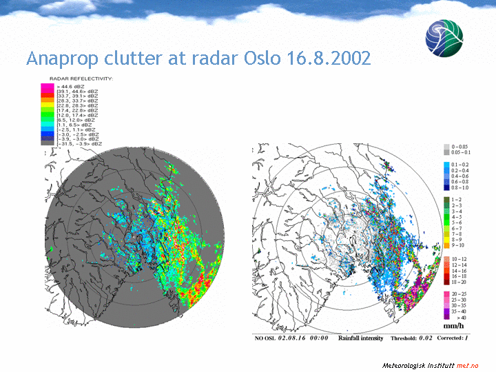
Seasonal variations of propagation conditions have been studied for the Barcelona region by Bech et al. (2002,2003). They show that normal propagation conditions are dominant, but there are significant seasonal variations in both the median and the monthly dispersion of the vertical refractivity gradient. For Norway, such statistics is not yet available, but anaprop clutter is observed frequently in the region of Østfold, southeast of radar Oslo. The attached figures show a case of beam splitting on August 16, 2002.
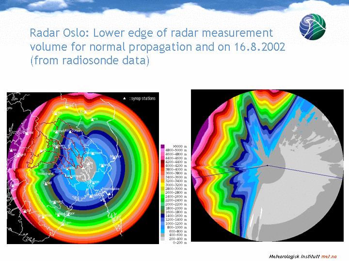
Partial blocking of the lowest elevation is present in all Norwegian radars except for radar Rissa. We expect also the new radar on Røst to be affected by beam blockage. The Bømlo radar has a 100% blockage in a sector of about 25 degrees in eastern direction. A model for deriving the percentage of beam blockage for each pixel has therefore been developed. Temperature- and humidity profiles are used as input. The data is taken from either radiosonde measurements or an NWP analysis.
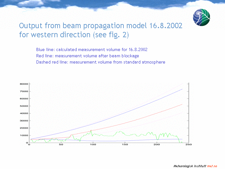
For the blockage correction, the lower limit of the measurement volume for each radar bin is calculated for each elevation. A number of beam traces are computed from radiosonde data using the altitude, the vertical angle, refractivity, atmospheric pressure, temperature and the partial pressure of water vapour as input. The beam trace is computed from curvature by a simple numerical method and used in a distributed model where each point is positioned in a cylindrical coordinate system. When a point on the topographic map is higher than the computed lower limit for the beam in the corresponding radar bin, the pre-calculated beam closest to the topographic data is used as minimum measurement height in that point. All parameters produced by the program can be checked by two-dimensional cuts for any azimuth angle out from the radar. The method is documented in Gjertsen and Dahl (2002).
Bech, J. (2002), B. Codina, J. Lorente, and D. Bebbington, Monthly and daily variations of radar anomalous propagation conditions: How "normal" is normal propagation?. Proceedings 2nd European Conference on Radar Meteorology: 35-39. Copernicus GmbH © 2002.
Bech J. (2003), Codina B., Lorente J., Bebbington D., The sensitivity of single polarization weather radar beam blockage correction to variability in the vertical refractivity gradient. J. Atmos. and Oceanic Technol., 20, 845-855.
Gjertsen, U., and J. I. Dahl, Challenges for precipitation estimation in mountainuous regions. Proceedings 2nd European Conference on Radar Meteorology: 250-254. Copernicus GmbH © 2002.